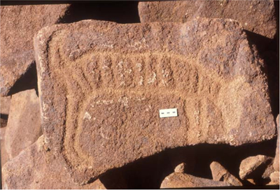
The Burrup peninsula is located on the Indian Ocean in the Pilbara region in North Western Australia. It is a 110 sq/km area part of the Dampier archipelago which includes 42 islands and islets mostly made up of pre-cambrian igneous rocks (i.e. lava) but also stromatolites ancient fossilised rocks some of the oldest on the earth’s surface (over 3 billion years). The Burrup is home to perhaps the World’s densest concentration of petroglyphs (engraved motifs). The Dampier archipelago features some 720 sites and between 500,000 and 1 million petroglyphs some dating at least 3,800 BP perhaps up to 30,000 year old. The petroglyphs includes depictions of Tasmanian tiger (Thylacines) – see photo – extinct on the mainland for over 3000 years, other animals include now extinct macropodes, numerous stylised turtles, aquatic birds, simple birds, emus, marine fauna, dugong, fish, sting rays, whales varied geometric motifs and most certainly some of the World’s oldest human portraits, depicting a comprehensive timeline of aboriginal graphic and spiritual genius. It was noted for its potential as a World Heritage Area about 25 years ago.
 [1] [1] |
 [2] [2] |
As a result of industrial development offshore and onshore, Woodside – Australia’s largest traders in oil and gas exploration and production company, Burrup Fertilisers the world’s largest Ammonia plant, Methanol plant, Dampier Nitrogen and a desalination plant, Dampier Island is now an artificial peninsula known as « Burrup Peninsula ».
This unique landscape rich both in terms of environmental diversity and Aboriginal cultural heritage is once again at threat as in the 1980’s when a large number of petroglyphs about 1800 were displaced or destroyed due to the construction of the Woodside Energy Limited liquefied gas plant and other constructions, some of the 1800 are now sited near the Burrup Fertiliser plant. The environment and the petroglyphs found in the Pilbara region are also susceptible to the degradation via atmospheric pollution from industrial exhausts.
Woodside’s Energy new extension project at Holden point Burrup “Pluto” has begun clearing potential protected areas, and some 60 pieces of petroglyphs rock art have already been displaced against Australian National Trust and before EPA’s approval.
Considering the immense value of these sites very little research has been carried out. Robin des Bois wishes the extension of Woodside’s Pluto project to be reconsidered and any future industrial or other re-developments in this region until the correct classification as a national heritage listing has been adequately considered.
Robin des Bois considers the Burrup as not only an Aboriginal but also a national and international concern. Robin des Bois supports the Australian National Trust position and Friends of Australian Rock Art, amongst others, that the displacement and potential destruction of the petroglyphs and further development in this region adversely affects what is probably one of Australia’s most significant heritage sites.
Robin des Bois is asking Federal Minister of Environment and Water Resources Hon. Malcolm Turnbull to make a decision on Friday, February 23rd, 2007 in favor of the National Heritage listing of the Dampier archipelago with due regard to “section 18” (approval to disturb indigenous heritage sites) for Pluto Site B.
Latest News : The Hon. Malcolm Turnbull has deferred his decision until August 2007.
Top: Striped animal, thought to be a thylacine (Tasmanian tiger)
Source : http://www.burrup.org.au/2006 – (Photo: JWR)
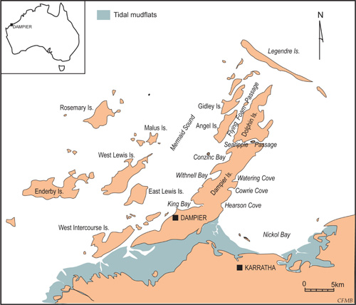
Map: The Dampier Archipelago
Source : http://www.burrup.org.au/2006